Petra
A very special day seeing one of the acknowledged wonders of the world, the rose colour city of Petra.
Situated between the Red Sea and the Dead Sea and inhabited since prehistoric times, the rock-cut capital city of the Nabateans, became during Hellenistic and Roman times a major caravan centre for the incense of Arabia, the silks of China and the spices of India, a crossroads between Arabia, Egypt and Syria-Phoenicia. Petra is half-built, half-carved into the rock, and is surrounded by mountains riddled with passages and gorges. An ingenious water management system allowed extensive settlement of an essentially arid area during the Nabataean, Roman and Byzantine periods. It is one of the world's richest and largest archaeological sites set in a dominating red sandstone landscape.
The Outstanding Universal Value of Petra resides in the vast extent of elaborate tomb and temple architecture; religious high places; the remnant channels, tunnels and diversion dams that combined with a vast network of cisterns and reservoirs which controlled and conserved seasonal rains, and the extensive archaeological remains including of copper mining, temples, churches and other public buildings. The fusion of Hellenistic architectural facades with traditional Nabataean rock-cut temple/tombs including the Khasneh, the Urn Tomb, the Palace Tomb, the Corinthian Tomb and the Deir ("monastery") represents a unique artistic achievement and an outstanding architectural ensemble of the first centuries BC to AD. The varied archaeological remains and architectural monuments from prehistoric times to the medieval periods bear exceptional testimony to the now lost civilisations which succeeded each other atthe site.
Criterion (i): The dramatic Nabataean/Hellenistic rock-cut temple/tombs approached via a natural winding rocky cleft (the Siq), which is the main entrance from the east to a once extensive trading city, represent a unique artistic achievement. They are masterpieces of a lost city that has fascinated visitors since the early 19th century. The entrance approach and the settlement itself were made possible by the creative genius of the extensive water distribution and storage system.
Criterion (iii): The serried rows of numerous rock-cut tombs reflecting architectural influences from the Assyrians through to monumental Hellenistic; the sacrificial and other religious high places including on Jebels Madbah, M'eisrah, Khubtha, Habis and Al Madras; the remains of the extensive water engineering system, city walls and free standing temples; garden terraces; funerary stelae and inscriptions together with the outlying caravan staging posts on the approaches from the north (Barid or Little Petra) and south (Sabra) also containing tombs, temples, water cisterns and reservoirs are an outstanding testament to the now lost Nabataean civilization of the fourth century BC to the first century AD.
Remains of the Neolithic settlement at Beidha, the Iron Age settlement on Umm al Biyara, the Chalcolithic mining sites at Umm al Amad, the remains of Graeco-Roman civic planning including the colonnaded street, triple-arched entrance gate, theatre, Nymphaeum and baths; Byzantine remains including the triple-apses basilica church and the church created in the Urn Tomb; the remnant Crusader fortresses of Habis and Wueira; and the foundation of the mosque on Jebel Haroun, traditionally the burial place of the Prophet Aaron, all bear exceptional testimony to past civilizations in the Petra area.
Criterion (iv): The architectural ensemble comprising the so-called "royal tombs" in Petra (including the Khasneh, the Urn Tomb, the Palace Tomb and the Corinthian Tomb), and the Deir ("monastery") demonstrate an outstanding fusion of Hellenistic architecture with Eastern tradition, marking a significant meeting of East and West at the turn of the first millennium of our era.
The Umm al Amad copper mines and underground galleries are an outstanding example of mining structures dating from the fourth millennium BC.
The remnants of the diversion dam, Muthlim tunnel, water channels, aqueducts, reservoirs and cisterns are an outstanding example of water engineering dating from the first centuries BC to AD.
Integrity (2010)
All the main free standing and rock-cut monuments and extensive archaeological remains within the arid landscape of red sandstone cliffs and gorges lie within the boundaries of the property that coincide with the boundaries of the Petra National Park. The monuments are subject to ongoing erosion due to wind and rain, exacerbated in the past by windblown sand due to grazing animals reducing ground cover. The resettlement more than twenty years ago of the Bdul (Bedouin) tribe and their livestock away from their former seasonal dwellings in the Petra basin to a new village at Umm Sayhun was aimed in part at arresting this process.
They are also vulnerable to flash flooding along Wadi Musa through the winding gorge (Siq) if the Nabataean diversion system is not continually monitored, repaired and maintained.
The property is under pressure from tourism, which has increased greatly since the time of inscription, particularly congestion points such as the Siq which is the main entrance to the city from the east.
The property is also vulnerable to the infrastructure needs of local communities and tourists. A new sewerage treatment plant has been provided within the property to the north with the recycled water being used for an adjacent drip irrigation farming project. Further infrastructure development proposed inside the boundary includes electricity supply and substation, a community/visitor centre, an outdoor theatre for community events, picnic areas, camping ground and a new restaurant near the Qasr al Bint temple, all of which have the potential to impact on the integrity of the property.
Authenticity (2010)
The attributes of temple/tomb monuments, and their location and setting clearly express the Outstanding Universal Value. The natural decay of the sandstone architecture threatens the authenticity of the property in the long-term. Stabilization of free standing monuments including the Qasr al Bint temple and the vaulted structure supporting the Byzantine forecourt to the Urn Tomb Church was carried out prior to inscription.
Protection and management requirements (2010)
Under Jordanian National law, responsibility for protection of Antiquities sites lies with the Department of Antiquities, a separate entity under the Ministry for Tourism and Antiquities.
The property is a protected area within the Petra Archaeological Park managed by the Ministry of Tourism and Antiquities. However responsibility for the overall planning and implementation of infrastructure projects at the site rests largely with the Petra Regional Authority (PRA) - originally the Petra Regional Planning Council (PRPC) - but now expanded to cover the social and economic wellbeing of the communities in the locality.
Increased staff numbers have enabled campaigns of inspection and control and strategies have been developed to manage tourist access and local community involvement, including the location and design of community-managed shop/kiosks.
Regulations and policies developed under the Petra Archaeological Park Operating Plan will cover infrastructure projects undertaken by the PRA including electrification of the Petra Archaeological Park and works associated with water recycling farming projects including tree-planting. They will also cover visitor facilities such as park lighting, tourist trails and interpretative signage, restaurants and shops, community recreation areas and businesses, as well as public events and activities within the park.
There is a long-term need for a framework for sustainable development and management practices aimed at protecting the property from damage resulting from the pressure of visitors, while enhancing revenues from tourism that will contribute to the economic and social viability of the region.
Inhabited since prehistoric times, the Nabataean caravan city of Petra, situated between the Red Sea and the Dead Sea, was an important crossroads between Arabia, Egypt and Syria-Phoenicia and bears a unique testimony of a disappeared civilization in which ancient Eastern traditions blended with Hellenistic architecture.
Petra lies south of modern Amman on the edge of the mountainous desert of Wadi Araba, surrounded by towering hills of sandstone which gave the city some natural protection against invaders. It was for centuries the meeting point of the main routes used by camel caravans transporting spices between the Mediterranean and the Near East, Africa and India. Petra was first established around the 6th century BC by the Nabataean Arabs, a Semitic people who laid the foundations of a commercial empire that extended into Syria. In AD 106 Trajan annexed the Nabataean Kingdom as part of the province of Arabia. The many earthquakes that hit Petra triggered a slow decline for the city, which was not halted by its designation as an Archiepiscopal See. The Arabs conquered the city in 636 but it remained distant from the pilgrim road to Mecca. The Crusaders constructed a fort there in the 12th century and Petra returned to its ancient splendour, but soon they withdrew, leaving Petra to the local people until the early 19th century, when it was visited by the Swiss explorer Burckhardt.
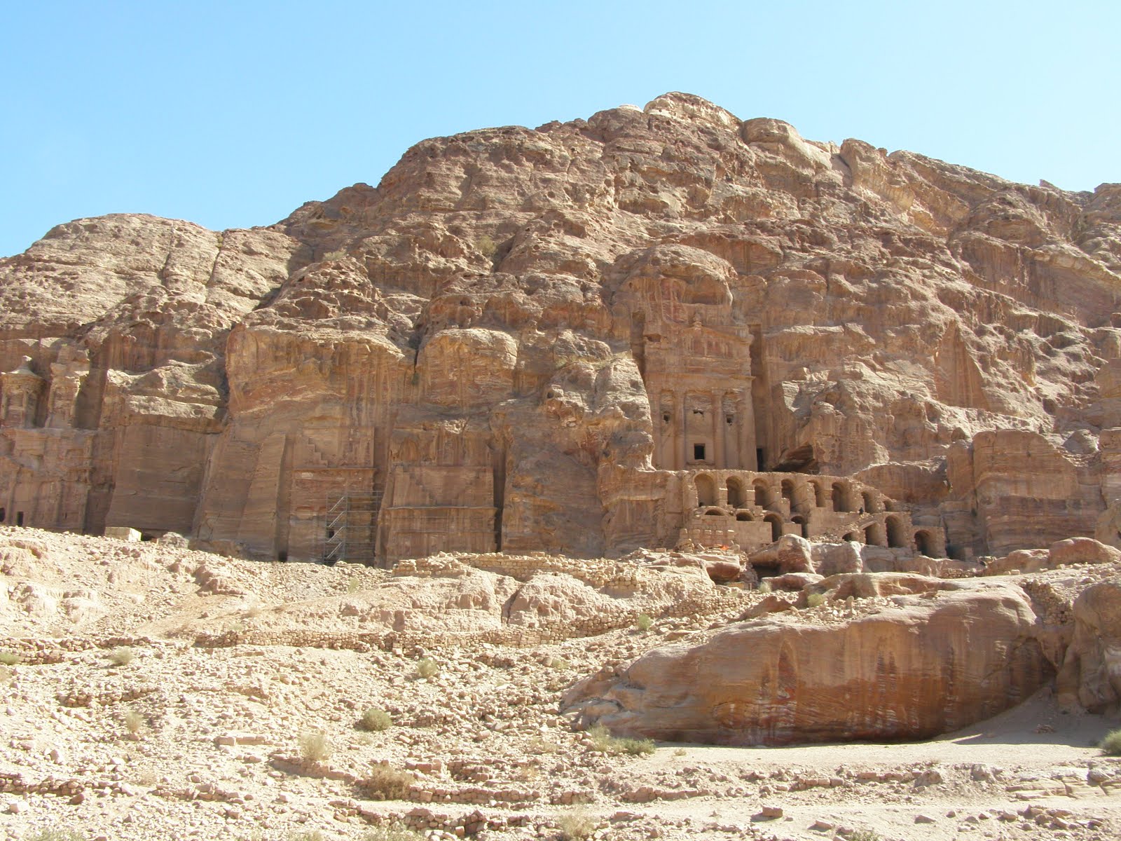
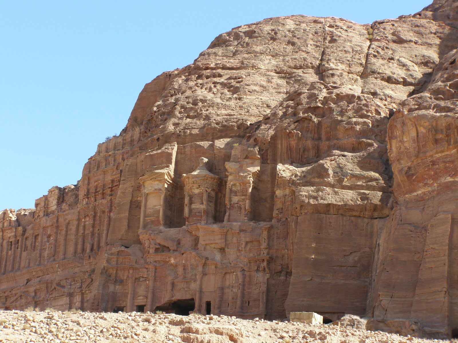
North from the Khazneh lies the massif of Jebel Khubtha. Three large structures (Royal Tombs) are carved into the rock face, which is known as the King's Wall.
First is the Urn Tomb, a well-preserved monument that faces on to an open terrace fronted by a double row of vaults. A colonnaded cloister runs along the northern side of the terrace. The elaborate facade fronts a single, unadorned room. The walls are smooth, the interior corners exact. The only decoration to be seen at present comes from the beautiful whorls of different-coloured sandstone in the walls, ceiling and floor of the chamber.
The Corinthian Tomb, a smaller version of the Khazneh, is followed by the Palace Tomb (Silk Tomb), named from the extraordinary chromatic effect of the rock.
Some distance away from the Royal Tombs, to the north, there is a tomb built in 130 for the Roman governor of the city under Hadrian, Sextius Florentinus.
The Khazneh el Faroun, or the Treasury of the Pharaoh, is an imposing facade standing some 40 m tall, cut directly from the rock of the mountainside. On the lower floor is a portico with six columns, crowned by floral capitals and surmounted by a fronton; the third floor is divided into three parts at the centre is a tholos with a conical roof, surmounted by a urn, and on either side two half-frontons, supported by columns. An architectural and sculptural decoration of the highest quality adorns the architecture elements and the front of the building. The Khazneh is the only rock-cut building in Petra that presents absolutely no Nabataean element and attests to link exclusively with the Alexandrian world and Hellenistic artistic traditions. Behind the impressive facade, a large square room has been carved out of the rock of the cliff. This is typical of the tombs in Petra; the interiors are as plain as the exteriors are intricate.
The Siq is the gorge formed by the torrent, the Musa, which the Nabataeans blocked with a dam and channelled to carry drinking water to the city; along the rock walls of the Siq there is a succession of inscriptions, niches and small votive altars, but also reliefs and sculptures that depict a caravan of men and camels. Once inside, the Siq narrows to little more than 5 m in width, whereas the walls tower up hundreds of metres on either side. The floor, originally paved, is now largely covered with soft sand, although evidence of Nabataean construction can still be seen in some places.
There are also noteworthy relics from Roman times: at the southern edge of the valley stands the 1st century AD theatre, carved almost entirely in the rock, which could hold more than 8,000 spectators, while at the end of the Siq the ruins open out of the colonnaded way. Set on a promontory that overlooks the valley of Petra to the west, accessible via a type of sacred stepped way cut into the rock, is another building with an imposing facade carved out of the rock: this is al-Dayr, the austerity and the simplicity of which join to demonstrate the original local version of elements of the Hellenistic tradition. The structure of the interior is devoid of any funeral installation.
I had been concerned about the walking involved in seeing Petra as I was aware of the steep inclines involved; however, the walk down was not a problem. The walk is divided into three stages and we slowly made our way back up from the bottom covering the first two stages back to the treasury and then after a short wait because of the crowd from a large cruise ship managed to arrange for a horse and carriage ride to the top (the steepest incline). We were both exhausted, but satisfied that we could cross off an items from our must see list.